6 Days Mount Kilimanjaro Shira Route
Very similar to Lemosho route, however it starts at 3,600 meters and is therefore not ideal for trekkers who have little or no experience of high altitude trekking.
On the first day, you begin at Shira Gate to Simba Camp before joining the Lemosho Route on day two at Shira Camp 2. The high starting point is however a major negative for this route as many experience altitude sickness from day one without enough time to acclimatize.
The route over the Shira Plateau has several possible variations. After Shira Camp 2 the route joins the Machame Route via Lava Tower, and then descends to the Barranco Camp via the Southern Circuit. Ascent to Uhuru Peak is made via Barafu Camp and up the southern slopes of Kibo.
The route is seldom used by other trekkers and so your initial two days on the mountain are less crowded than on most other routes.
- Duration: 6 – 7 days
- Difficulty: High
- Scenery: Excellent
- Traffic: Medium
SHIRA ROUTE ELEVATIONS

- Elevation: 1830m/6000ft to 3850m/12,600ft
- Distance: 8km/5mi
- Hiking Time: 4-5 hours
- Habitat: Montane Forest
The drive from Moshi to the trailhead takes about 3 hours. We hike through the rainforest on a winding trail up a ridge. At lower elevations, the trail can be muddy and slippery. Gaiters and trekking poles are a good idea here. We continue a short distance until we reach the Shira Camp. An overnight at Shira 2 Camp.
- Elevation: 3850m/12,600ft to 4000m/13,000ft
- Distance: 10km/6mi
- Walking Time: 5-6 hours
- Habitat: Semi-desert
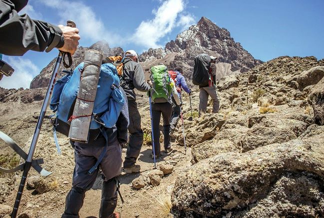
From the Shira Plateau, we continue to the east up a ridge, passing the junction towards the peak of Kibo. As we continue, our direction changes to the southeast towards the Lava Tower, called the “Shark’s Tooth” (elev 4650m/15,250ft). Shortly after the tower, we come to the second junction which goes to the Arrow Glacier. We now continue down to the Barranco Camp. Although you end the day around the same elevation as when you began, this day is very important for acclimatization and will help your body prepare for summit day. An overnight at Barranco Camp.
- Elevation: 4000m/13,000ft to 4050m/13,250ft
- Distance: 5km/3mi
- Hiking Time: 3-4 hours
- Habitat: Alpine Desert
After breakfast, we leave Barranco and continue on a steep ridge up the Barranco Wall to the Karanga Valley and the junction which connects with the Mweka Trail. An overnight at Karanga Camp.
- Elevation: 4050m/13,250ft to 4700m/15,350ft
- Distance: 4km/2mi
- Hiking Time: 3-4 hours
- Habitat: Alpine Desert
We continue up to the Barafu Camp. You have completed the South Circuit, which offers views of the summit from many different angles. Here we make camp, rest, enjoy dinner, and prepare for the summit day. An overnight at Barafu Camp.
- Elevation: 4700m/15,350ft to 5895m/19,340ft, down to 3090m/10,150ft
- Distance: 5km/3mi up / 13km/8mi down
- Hiking Time: 5-7 hours up / 5-6 hours down
- Habitat: Stone scree and ice-capped summit
Very early in the morning (midnight to 2 am), we continue our way to the summit between the Rebmann and Ratzel glaciers. You head in a northwesterly direction and ascend through heavy scree towards Stella Point on the crater rim. This is the most mentally and physically challenging portion of the trek. At Stella Point, you will stop for a short rest and will be rewarded with the most magnificent sunrise you are ever likely to see. Faster hikers may view the sunrise from the summit.
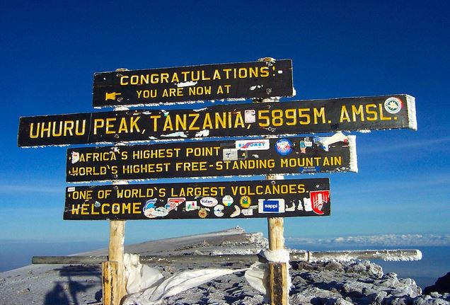
From Stella Point, you may encounter snow all the way on your 1-hour ascent to the summit. Once at Uhuru Peak, you have reached the highest point on Mount Kilimanjaro and the continent of Africa!
From the summit, we begin our descent by continuing straight down to the Mweka Camp, stopping at Barafu for lunch. You may want gaiters and trekking poles for the loose gravel going down. We arrive at Mweka Camp and enjoy our last evening on the mountain. An overnight at Mweka Camp.
- Elevation: 3090m/10,150ft to 1680m/5500ft
- Distance: 10km/6mi
- Hiking Time: 3-4 hours
- Habitat: Forest
After breakfast, we continue the descent down to the Mweka Park Gate to receive your summit certificates. At lower elevations, it can be wet and muddy. Gaiters and trekking poles will help. Shorts and t-shirts will probably be plenty to wear (keep rain gear and warmer clothing handy).
From the gate, continue another hour to Mweka Village. A vehicle will meet you at Mweka village to drive you back to your hotel in Moshi (about 30 minutes). You now drive back to Moshi for a long-overdue hot shower, dinner, and celebrations!! Overnight in The Maridadi hotel.
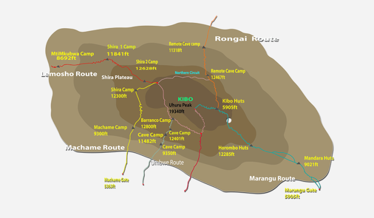
ITINERARY MAP
Trekking Costs
- Shira route 6 days 5 nights + 2 nights at the Hotel (Before and After the climb) is $2,385 per person
- Solo climber add-on charge: $350.
- Prices are subject to change depending on the current (at the time of booking) National park fees.
Crew List Idea for 2 Clients
- 1 Lead guide
- 1 Assistant guide
- 1 Cook
- 1 Waiter
- 1 Toilet porter (magic word: Pilot)
- 8 Regular porters
KILIMANJARO CLIMBING PRICE
Includes
Excludes
- Kilimanjaro trekking according to the itinerary
- Professional, English-speaking Wilderness First Responder & CPR certified Guide
- Proper Ration of Mountain crew (Cook & Porters)
- Pre and post accommodations (2 nights Bed and Breakfast)
- Airport Transfers
- Meals according to the itinerary
- Drinking water and Full Board Meals
- All National Park & Hut Fees, Crew Permits and VAT
- Fair and Sustainable Salary Crew Wages
- Gate Transfers
- Complimentary Oxygen Cylinder
- Portable private toilet and porter
- Quality imported equipment
- Flights
- Visa fees
- Travel or medical insurance
- Gamow Bag
- Medication
- Tips for porters and mountain crew (recommended $350 per person).
- Personal spending money for souvenirs, etc.
- Energy food & beverages, alcoholic and soft drinks.
- Personal hire gear such as trekking poles, sleeping bags, etc.
- Additional lodge nights for acclimatizing ($150 for one room bed and breakfast)
TRAVELER PHOTOS

KILIMANJARO TRAVEL GUIDE
Get your free Kilimanjaro Trekking Guide for an unforgettable adventure! Discover trekking costs, the best time to visit, and more!