
8 Days Mount Kilimanjaro Northern Circuit Route
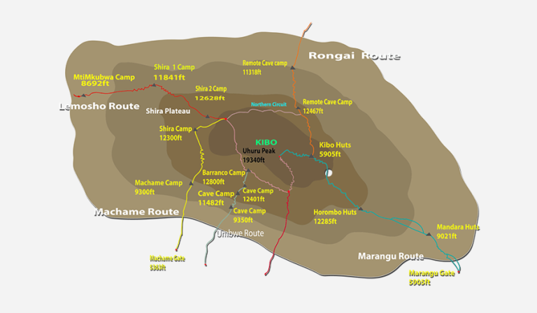
There are six established routes to climb Mount Kilimanjaro – Marangu, Machame, Lemosho, Shira, Rongai, and Umbwe. The Marangu, Machame, and Umbwe routes all approach from the south of the mountain. The Lemosho and Shira routes approach from the west. The Rongai route approaches from the north. All routes except Marangu and Rongai descend via the Mweka route.
The Northern Circuit route is one of the best routes on Kilimanjaro, offering nearly 360 degrees of beautiful scenery including the quiet, rarely visited northern slopes. As the longest route on Kilimanjaro, the Northern Circuit allows for the best acclimatization time and the highest summit success rate, therefore this route is highly recommended.
The route approaches Mount Kilimanjaro from the west, beginning with a long drive from Moshi to Londorossi Gate. From there, the first two days are spent trekking through the rainforest to Shira Ridge, before crossing the Shira Plateau. The route then heads north and circles clockwise from Moir Hut to Buffalo Camp to School Hut, before summiting from the east.
- Duration: 8 or 10 days
- Difficulty: Medium
- Scenery: Excellent
- Traffic: Low
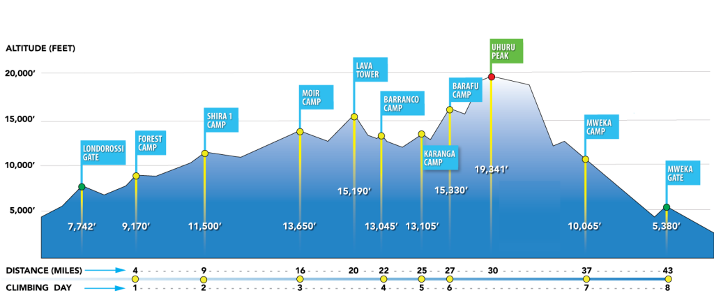
NORTHERN CIRCUIT ROUTE ELEVATIONS
Upon arrival at Kilimanjaro International Airport, you will be met and transferred for overnight accommodation at The Maridadi Hotel B&B. Your head guide will meet you for your briefing, gear check, and to arrange for you to hire any equipment you may need.
- Elevation: 2389m/7838ft to 2785m/9137ft
- Altitude Gained: 396m
Departing from Moshi, a 3-hour drive will take you through welcoming mountainside villages to the Kilimanjaro National Park Gate. We will patiently wait for our permits to be issued while watching the hustle and bustle of operations as many crews prepare for the journey ahead. Enjoy the beautiful
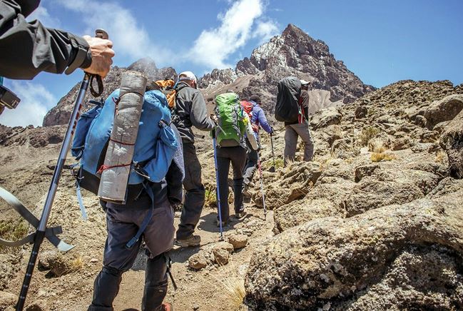
rainforest scenery and windy trails while your guide tells you about the local flora, fauna, and natural wildlife. At these lower elevations, the trail can be muddy and quite slippery. We highly recommend gaiters and trekking poles here.
- Elevation: 2785m/9137ft to 3504m/11,496ft
- Altitude Gained: 719m
After a good night’s sleep and a hearty breakfast, we emerge from the rainforest and continue on an ascending path. We leave the forest behind now, and the trail climbs steadily with wide views to reach the rim of the Shira Plateau. Temperatures begin to drop.
- Elevation: 3504m/11,496ft to 3895m/12,779ft
- Altitude Gained: 391m
Our trek crosses the Shira Plateau, one of the highest plateaus on Earth, from Shira I Camp to Shira II Camp. Nine-day climbs will stay the night at Shira II Camp, joining climbers ascending from the Machame Route. At Shira II Camp, it is worth the extra energy to go a bit higher up the plateau to enjoy the stunning view across the valley below and view the Western Breach of Kilimanjaro above. The plateau is exposed, so be prepared for a cold night with temperatures getting below zero.
Note: 8-day climbs continue east to Shira Plateau Ridge to Lava Tower (4,600 meters) and descend to Moir Camp (4,200 meters).
- Elevation: 3895m/12,779ft to 3986m/13,077ft
- Altitude Gained: 91m
Although you end the day around the same elevation as when you began, this day is very important for acclimatization. From Shira Plateau, we continue east up a ridge, passing the junction towards Kibo peak before we continue southeast towards the Lava Tower, called the “Shark’s Tooth” (elev. 4650m/15,250ft). Shortly after the tower, we come to a second junction, which leads to the Arrow Glacier. We then continue to descend to overnight at Moir Camp.
- Elevation: 4155m/13,632ft to 4033m/13,232ft
- Altitude Lost: 122m
We begin with a moderately steep climb out of Moir Valley. If you wish, take a small detour here to climb the summit of Little Lent Hill at 4,375 meters before returning to the Northern Circuit trail. The route follows a series of inclines and declines, skirting around the northern slopes of Kibo to Buffalo Camp. Spectacular views of plains north of Kilimanjaro stretch as far as the eye can see to the Kenyan/Tanzanian border. You will arrive at Buffalo Camp just after midday, where you will have lunch and time to rest.
- Elevation: 4033m/13,232ft to 3936m/12,193ft
- Altitude Lost: 97m
Day six starts with a climb up the Buffalo Ridge and down into Pofu Camp where lunch is served. We continue east around the northern slopes to the Rongai Third Cave. Today’s climb is shorter than the day before, and you should be feeling better acclimatized to the altitude at this point. You will arrive at the Third Cave just around mid-afternoon.
- Elevation: 3936m/12,913ft to 4717m/15,476ft
- Altitude Gained: 781m
A steady ascent over the Saddle, which sits between the peaks of Kibo and Mawenzi Peak. Continue southwest to School Hut, where you will be served an early dinner and rest as you will begin just before midnight to start your summit attempt. Remember to prepare all your gear, including warm clothes, insulated water bottles, snacks, headlamp, and camera before going to bed.
- Elevation: 4717m/15,476ft to 5895m/19,341ft
- Altitude Gained: 1178m
- Descent to: 3106m/10,190ft
- Altitude Lost: 2789m
Excitement builds as morning comes with an early start between midnight and 2 a.m. This is the most mentally and physically challenging portion of the trek. We continue our way to the summit between the Rebmann and Ratzel glaciers, trying to stay warm and focused on the amazing sense of accomplishment that lies ahead. With a switchback motion in a northwesterly direction, we ascend through heavy scree towards Stella Point on the crater rim. You will be rewarded with the most magnificent sunrise during your short rest here. Faster hikers may view the sunrise from the summit. From here, your remaining 1-hour ascent to Uhuru Peak will likely encounter snow all the way.
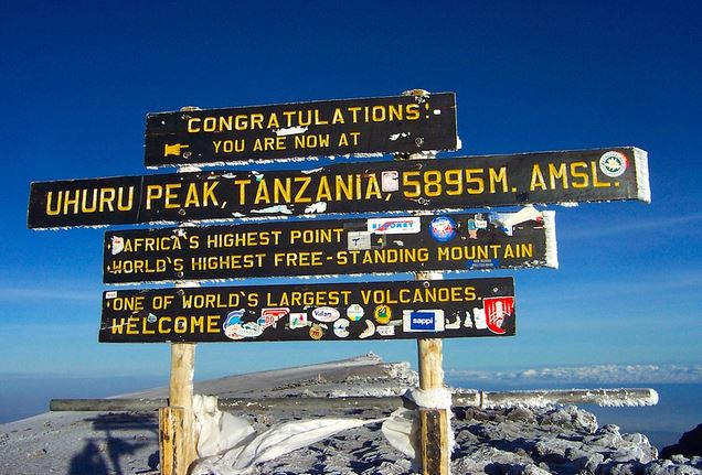
Congratulations! One step at a time, you have now reached Uhuru Peak, the highest point on Mount Kilimanjaro and the entire continent of Africa!
After photos, celebrations, and maybe a few tears of joy, we take a few moments to enjoy this incredible accomplishment. We begin our steep descent down to Mweka Camp, stopping at Barafu for lunch and a very brief rest. We strongly recommend gaiters and trekking poles for uncooperative loose gravel and volcano ash terrain. A well-deserved rest awaits you to enjoy your last evening on the mountain. Overnight at Mweka Camp.
- Elevation: 3106m/10,190ft to 1633m/5358ft
- Altitude Lost: 1473m
After breakfast and a heartfelt ceremony of appreciation and team bonding with your crew, it’s time to say goodbye. We continue the descent down to the Mweka Park Gate to receive your summit certificates. As the weather is drastically warmer, the terrain is wet, muddy, and steep. We highly recommend gaiters and trekking poles.
From the gate, a vehicle will meet you at Mweka village to drive you back to your hotel in Moshi (about 30 minutes). Enjoy a long overdue hot shower, dinner, and celebrations!
Overnight at The Maridadi Hotel B&B before being transferred to your journey home, safari, or a relaxing trip to Zanzibar.
ITINERARY MAP
Trekking Costs
- Northern Circuit 9 Days 8 Nights: $2,970 per person
- Solo climber add-on charge: $350.
Crew List Idea for 2 Clients
- 1 Lead guide
- 1 Assistant guide
- 1 Cook
- 1 Waiter
- 1 Toilet porter (magic word: Pilot)
- 8 Regular porters
- Prices quoted are subject to current Government Regulated Park Fees at the time.
KILIMANJARO CLIMBING PRICE
Includes
Excludes
- Kilimanjaro trekking according to the itinerary
- Professional, English-speaking Wilderness First Responder & CPR certified Guide
- Proper Ration of Mountain crew (Cook & Porters)
- Pre and post accommodations (2 nights Bed and Breakfast)
- Airport Transfers
- Meals according to the itinerary
- Drinking water and Full Board Meals
- All National Park & Hut Fees, Crew Permits and VAT
- Fair and Sustainable Salary Crew Wages
- Gate Transfers
- Complimentary Oxygen Cylinder
- Flights
- Visa fees
- Travel or medical insurance
- Gamow Bag
- Medication
- Tips for porters and mountain crew (recommended $350 per person).
- Personal spending money for souvenirs, etc.
- Energy food & beverages, alcoholic and soft drinks.
- Personal hire gear such as trekking poles, sleeping bags, etc.
- Additional lodge nights for acclimatizing ($150 for one room bed and breakfast)
TRAVELER PHOTOS

KILIMANJARO TRAVEL GUIDE
Get your free Kilimanjaro Trekking Guide for an unforgettable adventure! Discover trekking costs, the best time to visit, and more!