
8 Days Mount Kilimanjaro Northern Circuit Route
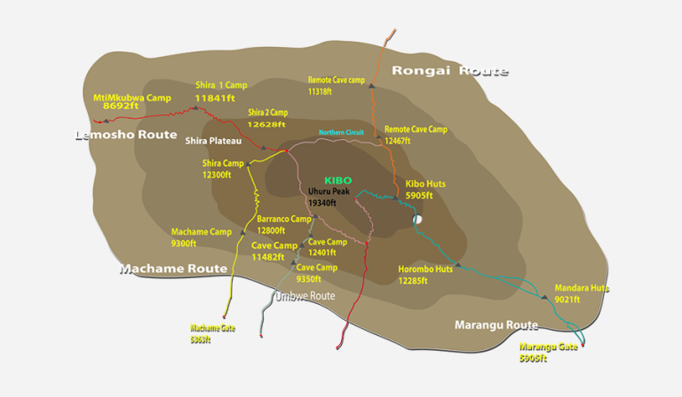
There are six established routes to climb Mount Kilimanjaro – Marangu, Machame, Lemosho, Shira, Rongai and Umbwe. The Marangu, Machame, and Umbwe routes all approach from the south of the mountain. The Lemosho and Shira routes approach from the west. The Rongai route approaches from the north near Kenya. All routes except Marangu and Rongai descend via Mweka.
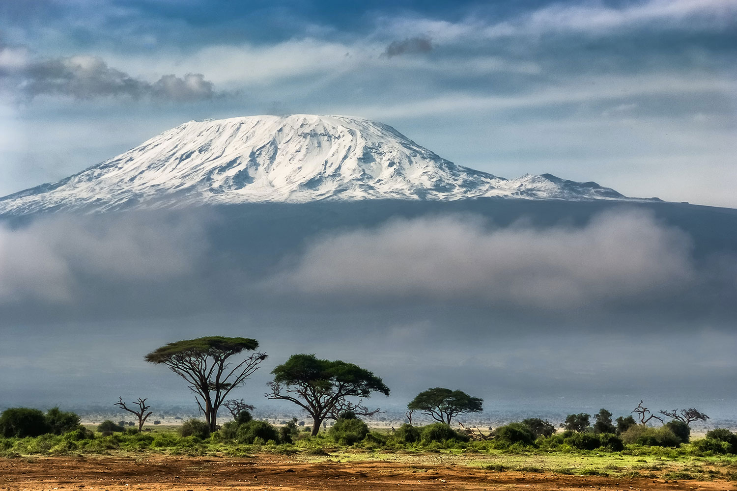
The Northern Circuit is one of the best routes on Kilimanjaro, offering nearly 360 degrees of beautiful scenery, including the quiet, rarely visited northern slopes. As the longest route on Kilimanjaro, the Northern Circuit allows for the best acclimatization time and the highest summit success rate. Therefore, this route is highly recommended.
The route approaches Mount Kilimanjaro from the west, beginning with a long drive from Moshi to Londorossi Gate. The first two days are spent trekking through the rainforest to Shira Ridge before crossing the Shira Plateau. The route then heads north and circles clockwise from Moir Hut to Buffalo Camp to School Hut, before summiting from the east.
- Duration: 8 or 10 days
- Difficulty: Medium
- Scenery: Excellent
- Traffic: Low
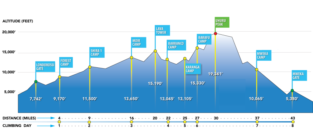
NORTHERN CIRCUIT ROUTE ELEVATIONS
Upon arrival at Kilimanjaro International Airport, you will be met and transferred for overnight accommodation at The Maridadi Hotel B&B. Your head guide will meet you for your briefing, gear check, and to arrange for you to hire any equipment you may need.
- Elevation: 2389m / 7838ft to 2785m / 9137ft
- Altitude gained: 396m
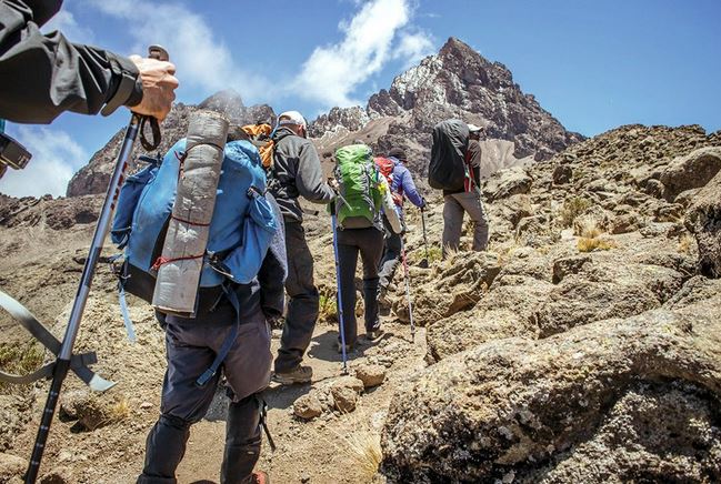
Departing from Moshi, a 3-hour drive will take you through welcoming mountainside villages to the Kilimanjaro National Park Gate. We will patiently wait for our permits to be issued while watching the hustle and bustle of operations as many crews prepare for the journey ahead. Enjoy the beautiful rainforest scenery and winding trails while your guide tells you about the local flora, fauna, and natural wildlife. At these lower elevations, the trail can be muddy and quite slippery. We highly recommend gaiters and trekking poles here.
- Elevation: 2785m / 9137ft to 3504m / 11496ft
- Altitude gained: 719m
You will spend the first hour trekking through the last section of the rainforest path before entering the low alpine moorland zone, which follows up onto the Shira Plateau. The trek is relatively short and gradual, ending at Shira Camp 1 (3,504 meters).
- Elevation: 3504m / 11496ft to 4161m / 13651ft
- Altitude gained: 657m
A long trek heading east passes through the ‘Garden of the Senecios’ and then enters the high alpine desert zone. The morning is spent trekking up to Lava Tower and the iconic Shark’s Tooth rock formation at 4,600 meters, where you will have lunch. After lunch, you will join the northern circuit heading down to Moir Camp at 4,161 meters. This is an important day in your trek as you will experience high altitude and then sleep low, which is good for the acclimatization process.
- Elevation: 4161m / 13651ft to 4033m / 13232ft
- Altitude lost: 122m
Today involves a moderately steep climb out of Moir Valley. Trekkers can take a small detour here to climb the summit of Little Lent Hill at 4,375 meters before returning to the Northern Circuit trail. From here, the route follows a series of inclines and declines, skirting around the northern slopes of Kibo to Buffalo Camp. The trek gives great vistas out across the plains that lie north of Kilimanjaro and stretch out to the Kenyan/Tanzanian border. You will arrive at Buffalo Camp just after midday, where you will have lunch and have time to rest after a long day of hiking.
- Elevation: 4033m / 13232ft to 3936m / 12193ft
- Altitude lost: 97m
Starts with a climb up the Buffalo Ridge and down into Pofu Camp where lunch is usually served. The route then continues east around the northern slopes to the Rongai Third Cave at 3,936 meters. The trek is shorter than the day before and by now you should be feeling well acclimatized to the altitude. You will arrive at the Third Cave just around mid-afternoon.
- Elevation: 3936m / 12193ft to 4717m / 15476ft
- Altitude gained: 781m
Today involves a steady incline up and over the Saddle, which sits between the peaks of Kibo and Mawenzi Peak. Trekkers then continue walking southwest up to School Hut (4,800 meters). After arriving at School Hut, you will be served an early dinner and then you should get some shut-eye as you will be awoken before midnight to start your summit attempt. Remember to prepare all your gear, including warm clothes, insulated water bottles, snacks, headlamp, and camera before going to bed.
- Elevation: 4717m / 15476ft to 5895m / 19341ft to 3827m / 12556ft
- Altitude gained: 1178m
- Altitude lost: 2068m (descent)
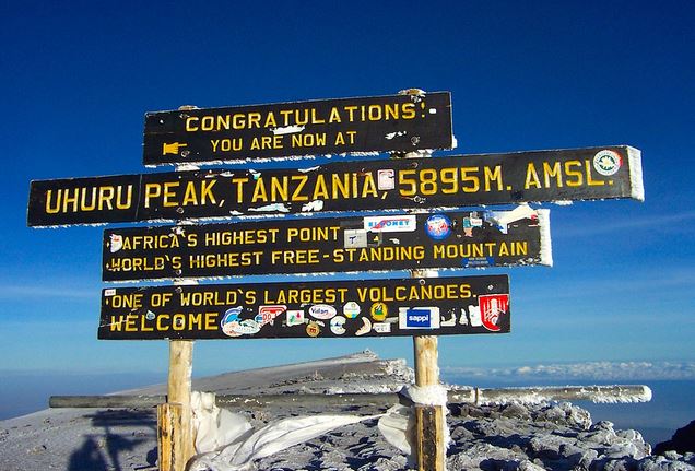
You will be awoken around 11:30 PM with hot tea and biscuits and will then begin the steep incline up to the slopes of Kibo under the cover of darkness. Your first checkpoint is Hans Meyer Cave where you will take a short break. The climb steepens as you approach Gilman’s Point (5,681 meters), which will be around 5-6 hours after departing School Hut. Take a moment to enjoy the approaching dawn and incredible view out and across to Mawenzi Peak, but remember you still have 2 hours of trekking to reach Uhuru Peak, so dig deep for the energy. The slope flattens as you head west around the crater rim and you should arrive at the summit at or just after sunrise. Your stay here will be brief, so get as many pictures as you can of the incredible views and surrounding glaciers. You will then retrace your steps back around the crater rim to Stella Point (5,739 meters) where you will turn south and head down the heavily screed slopes of Kibo to Barafu Camp (4,680 meters). Most trekkers take a short break here before continuing down to Millennium Camp (3,950 meters) for your final night on the mountain. In total, you will be trekking for 14-16 hours on day eight, so it is important to pace yourself, remain hydrated, and keep your blood sugar levels up.
- Elevation: 3827m / 12556ft to 1633m / 5358ft
- Altitude lost: 2194m
After breakfast and a heartfelt ceremony of appreciation and team bonding with your crew, it’s time to say goodbye. We continue the descent down to the Mweka Park Gate to receive your summit certificates. As the weather is drastically warmer, the terrain is wet, muddy, and steep, and we highly recommend gaiters and trekking poles.
From the gate, a vehicle will meet you at Mweka Village to drive you back to your hotel in Moshi (about 30 minutes). Enjoy a long-overdue hot shower, dinner, and celebrations!
Overnight at The Maridadi Hotel B&B before being transferred to your journey home, safari, or a relaxing trip to Zanzibar.
ITINERARY MAP
Trekking Costs
- Lemosho 8 days, 7 nights: $2718 per person.
- Solo climber add-on charge: $350.
Crew List Idea for 2 Clients
- 1 Lead guide
- 1 Assistant guide
- 1 Cook
- 1 Waiter
- 1 Toilet porter (magic word: Pilot)
- 8 Regular porters
- Prices quoted are subject to current Government Regulated Park Fees at the time.
KILIMANJARO CLIMBING PRICE
Includes
Excludes
- Kilimanjaro trekking according to the itinerary
- Professional, English-speaking Wilderness First Responder & CPR certified Guide
- Proper Ration of Mountain crew (Cook & Porters)
- Pre and post accommodations (2 nights Bed and Breakfast)
- Airport Transfers
- Meals according to the itinerary
- Drinking water and Full Board Meals
- All National Park & Hut Fees, Crew Permits and VAT
- Fair and Sustainable Salary Crew Wages
- Gate Transfers
- Complimentary Oxygen Cylinder
- Flights
- Visa fees
- Travel or medical insurance
- Gamow Bag
- Medication
- Tips for porters and mountain crew (recommended $350 per person).
- Personal spending money for souvenirs, etc.
- Energy food & beverages, alcoholic and soft drinks.
- Personal hire gear such as trekking poles, sleeping bags, etc.
- Additional lodge nights for acclimatizing ($150 for one room bed and breakfast)
TRAVELER PHOTOS
KILIMANJARO TRAVEL GUIDE
Get your free Kilimanjaro Trekking Guide for an unforgettable adventure! Discover trekking costs, the best time to visit, and more!